Nepean Highway runs south from the centre of Melbourne to Portsea, along the eastern shore of Port Phillip. It is the primary road route to central Melbourne from Melbourne's southern suburbs.
History[]
Originally known as Arthurs Seat Road it was built in the 1850s to provide a road (originally a crude sandy track) from the farms (owned by Alexander Balcombe) south of Melbourne and link the city with its southern bay settlements and sea defences at Point Nepean. By the turn of the 20th century it had come to be known as Point Nepean Road and in 1948 was officially named Nepean Highway (indirectly after the British Politician and Colonial Administrator, Sir Evan Nepean, 1st Baronet PC (1751–1822)).
Between the 1950s and about 1980, the road was progressively upgraded to a divided highway between the City and Mordialloc. From Mordialloc to Frankston, the highway is an undivided four lane road. The widening of the Mordialloc Bridge, , the last section section of less than four lanes, was completed in early 2009.
The Nepean Highway has kept the old signage throughout the suburbs but is designated at the town of Mornington.
Route[]
Melbourne to Mornington[]
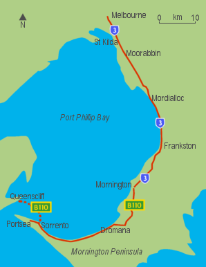
The road that is the Nepean Highway begins at the end of Swanston Street at the corner of Flinders Street, in the Melbourne CBD, and crosses the Princes Bridge where its name changes to become St Kilda Road, a leafy four lane boulevard shared with trams. It passes the Victorian Arts Centre (where the road number begins) and the Shrine of Remembrance before reaching St Kilda Junction. Shortly after, at the junction with Carlisle Street, there is another name change to Brighton Road. Then, at Glen Huntly Road, Elsternwick, it becomes the Nepean Highway. The Route 67 Carnegie Tram runs down the middle of the highway until it turns into Glen Huntly Road.
At Glen Huntly Road, the speed limit increases to 80 km/h and the road widens to become an eight-lane divided highway. It is reduced to six lanes at Moorabbin, passing through Cheltenham and Mentone, and then to the 60 km/h or 70 km/h four-lane single carriageway after the roundabouts at Mordialloc. The highway then travels virtually along the foreshore of Port Phillip Bay, to Frankston, with several stretches of dual carriageway, and then up Olivers Hill, from which there are good views across Frankston and the bay.
Mornington Peninsula[]
Just after passing through Mount Martha, the highway joins with the Mornington Peninsula Freeway, before turning toward the town of Dromana. Here the highway changes name again, to become Point Nepean Road – which was the former name of the entire highway in the early years of settlement. From here, Arthurs Seat is easily accessible, which gives spectacular views across the bay, and on a clear day, the skyscrapers of Melbourne are visible. Anthonys Nose is a point, or escarpment located on the southern shore of Port Phillip Bay, between Dromana and McCrae. The highway passes between "The Nose" and the shores of the bay. It was named by Charles La Trobe in 1839. In the 1920s "The Nose" was modified in order to combat the daily tides that blocked the highway.
leaves the highway at Sorrento to cross the bay to Queenscliff, via the ferry where it continues to Geelong, via Bellarine Highway, but the highway continues as a two lane road down to the seaside resort of Portsea. The end of the highway is the very nondescript painted turning circle, before the gates of the former Commonwealth quarantine and defence station of Point Nepean, a humble ending to Melbourne's main southern highway.