| Yarra River | |
|---|---|
| |
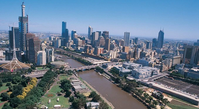
| The Yarra running through Melbourne | |
Some attributes
| |
| First | Name origin:
Wurundjeri |
| Second | Length:
242 km (150.4 mi) |
| Third | Discharge:
Mouth |
Other attributes
| |
The Yarra River, is a river in east-central Victoria, Australia. The lower stretches of the river is where the city of Melbourne was established in 1835 and today Greater Melbourne dominates and influences the landscape of its lower reaches. From its source in the Yarra Ranges, it flows 242 km west through the Yarra Valley which opens out into plains as it winds its way through Greater Melbourne before emptying into Hobsons Bay in northernmost Port Phillip.
The river was a major food source and meeting place for indigenous Australians from prehistoric times. Shortly after the arrival of European settlers land clearing forced the remaining Wurundjeri to neighbouring territories and away from the river. Originally called Birrarung by the Wurundjeri, the current name was mistranslated from another Wurundjeri term; Yarra Yarra, which means "ever flowing river".
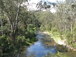
The Yarra River through Pound Bend near Warrandyte.
The river was utilised primarily for agriculture by early European settlers. The landscape of the river has changed dramatically since 1835. The course has been progressively disrupted and the river widened in places. The first of many Crossings of the Yarra River to facilitate transport was built in Princes Bridge. Beginning with the Victorian gold rush it was extensively mined, creating the Pound Bend Tunnel in Warrandyte, and the Big and Little Peninsula Tunnels above Warburton . Widening and dams, like the Upper Yarra Reservoir have helped protect Melbourne from major flooding, The catchment's upper reaches are also affected by logging. Industrialisation ultimately led to the destruction of the marshlands at the confluence of the Yarra and Maribyrnong Rivers in the area around Coode Island in West Melbourne.
Today, the mouth and including Swanston and Appleton Docks are used for container shipping by the Port of Melbourne, the busiest on the continent. The city reach which is inaccessible to larger watercraft, has seen increased use for both transport and recreational boating (including kayaking, canoeing, rowing and swimming). In recent years however recreational use of the river is threatened by high levels of pollution in its lower stretches. The upper reaches remain relatively healthy.
The annual Moomba festival celebrates the Yarra River's increasing cultural significance to Melbourne.
Geography[]

of Yarra River and its tributaries.
The Yarra River has a detailed and complex geological history, see "Geology". It was utilised and managed sustainably by the Wurundjeri for around 40,000 years, however since the European settlement and use of the river in the mid-19th century, its geography has changed substantially reflecting the unsustainable use of the river and surrounding resources. The river is fed by a number of small unnamed creeks and streams in the Yarra Ranges as well as 49 named tributaries, most of which are creeks. The river's lower reaches travel through central Melbourne. It is approximately 242 kilometres (150 mi) in length, with a mean annual flow of 718 gigalitres (2.54×10¹⁰ cu ft), which is roughly 50% its original flow prior to damming. It is the most westerly snow fed river in Australia. The total catchment area is approximately 4,000 square kilometres (1,500 sq mi).
Tributaries and geographic features[]
The Yarra's major tributaries are the Maribyrnong River, Moonee Ponds Creek, Merri Creek, Darebin Creek, Plenty River, Mullum Mullum Creek and Olinda Creek. The river hosts many geographical features such as; bends, rapids, lakes, islands, floodplains, billabongs and wetlands. Most features have been named after translated Wurundjeri phrases or have European, particularly British, origins. Some of the river's more prominent features include; Coode Island and Fishermans Bend, Victoria Harbour, Herring Island, Yarra Bend, Dights Falls, Upper Yarra Dam and Reservoir and many river flats and billabongs.
Settlements[]
- Greater Melbourne – 4 million
- Melbourne City Centre – 20,500
- South Yarra – 18,000
- Richmond – 22,500
- Hawthorn – 20,000
- Fairfield – 5,000
- Heidelberg – 5,300
- Bulleen – 10,500
- Templestowe – 16,500
- Eltham – 17,600
- Warrandyte – 10,000
- Yarra Glen – 2,600
- Healesville – 6,500
- Woori Yallock – 2,800
- Launching Place – 2,600
- Yarra Junction – 1,700
- Warburton – 2,300
- McMahons Creek – 282